Bomdila is a beautiful small town situated at a height of about 8000
ft. above the sea level from where one can see the brilliant landscape
and snow-clad mountains of the Himalayan Range. The Buddhist monastery
of Bomdila is the repository of culture and is among primary attractions
of the area.
Bomdila is the headquarters of West Kameng district located at the height of 8500 ft above the sea level. It has a lot of attractions for the tourists with its cool climate, Apple orchards, artistic people, snow-capped Himalayan peaks and Buddhist Gompas. The Buddhist monastery of Bomdila is the repository of culture.. This place has a tourist lodge, a craft centre displaying local crafts and a shopping centre where the visitors gets first feel of the local version of Himalayan Buddhist life.
Local site seeing to Dirang valley and the famous Sela Pass (13,700 ft. M.S.L.) are thrilling experience on the way to Tawang. The Orchid Research and Development Station at Tippi and two other Orchid conservation sanctuaries located at Sessa and Dirang are worth seeing places.
When to visit During the period April to October.
How to reach By bus and car from Tezpur, Guwahati (Assam).
Where to stay Circuit House, Tourist Lodge, Hotel La, Hotel Sweet.
Clothing Warm clothing during winters.
Nearest Airport Tezpur, Assam.
Nearest Bus stand Tezpur, Assam.
Nearest Railway Stn Rangapara, Assam.
What to see Craft centre producing very fine carpets of colourful designs and masks and Buddhist Monasteries.
Tourist Destinations in BomdilaWith snow clad Himalayan mountain ranges and lush greenery to flaunt its natural beauty and various crafts to boast of its rich culture and lifestyle, Bomdila ranks amongst the leading tourist destinations in Arunachal Pradesh. Situated 8000 feet above sea level, Bomdila is a photographer’s delight, as the snow-capped mountain ranges of Himalayas offer spectacular views. To enjoy the essence of nature in its varied forms, you could not think of a better place than Bomdila. Make sure that you do not miss the leading 12 places to visit in Bomdila.
1.
Sessa Orchid SanctuaryEstablished in the year 1979, Sessa Orchid Sanctuary covers more than 100 sq. km area of land. Doimara and Tenga reserve forests form a part of the sanctuary. Sessa Orchid Sanctuary has deep valleys, high hills as well as hills of lesser heights. Several rivers originate from these hills and the area thus looks picturesque with hills, valleys, rivers and waterfalls along with over 200 species of orchids. It also houses animals including red panda and pheasant. The sanctuary is beauty personified on all seasons of the year. While it rains mostly between April and October, during winter, high mountain peaks covered with snow make the environment stunningly beautiful.
2.
Eaglenest Wildlife SanctuaryClose to Sessa Orchid Sanctuary, you will find Eaglenest Wildlife Sanctuary, which covers an area of 217 sq. km. The sanctuary offers spectacular views with waterfalls flowing from lesser heights and Kameng River flowing through the lush greenery. The sanctuary is home to various birds like eagle, hornbill, kingfishers, ducks and pheasants. The animals found here include Bengal tiger, langur, Asian elephant, black bear, red panda and many more. Over 165 types of butterflies that are seen here add color to the colorful sanctuary.
3.
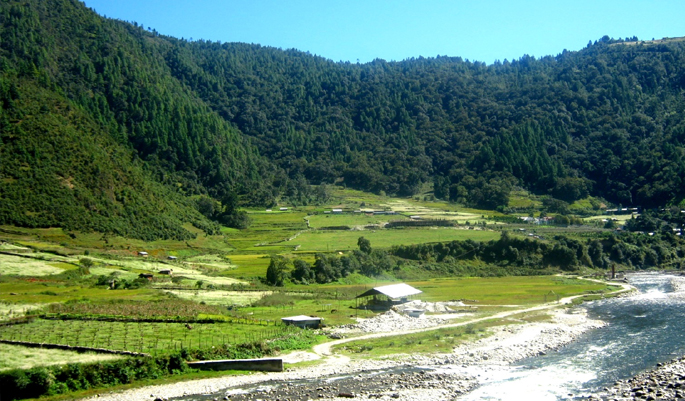
Dirang ValleyDirang Valley is a stunningly picturesque valley that lies between Bomdila and Tawang. Dirang, the town situated in the valley has a pleasant weather that makes for a comfortable stay. The views from Dirang are mind blowing. If you love trekking, you would the high peaks in Dirang irresistible. Dirang is also famous for hot water springs and apple orchards that enhance the natural beauty of the place. Bird watchers and trekkers use Dirang as their base camp before venturing towards Mandla. Dirang valley is also famous for medicinal plants that are found in plenty here.
4.
Bomdila MonasteryBomdila Monastery was established in the year 1965 and it represents the spiritual essence of Buddhism. It is situated close to Tipi Orchid Research Center in West Kameng district. Followers of Mahayana Buddhism consider this place sacred. The monastery resembles Tsona Gontse Monastery of South Tibet. The temple of Buddha in the monastery attracts pilgrims in great numbers.
5.
Apple OrchardsBomdila is famous for apple orchards. They are spread across large areas of the land. Laden with apples, the huge trees in the orchards are great attractions to tourists. Visiting Bomdila in winter would be a feast to your eyes as apple orchards will be at their optimum best in production. You are sure to love the casual stroll in the apple orchards and the temptation to buy apples for unbelievably low prices is too hard to resist.
6.
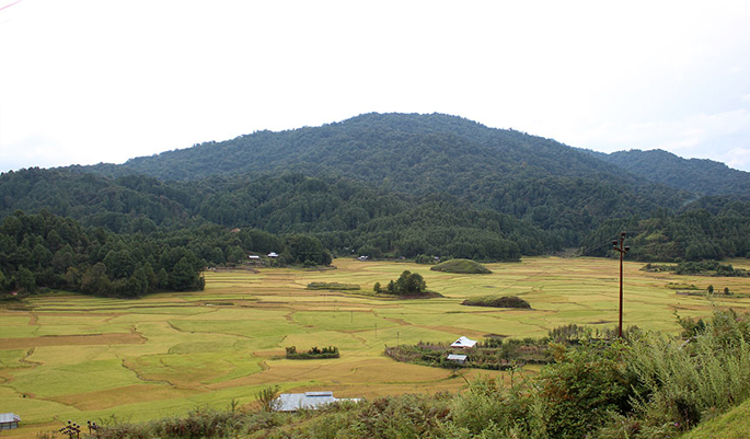
Bomdila View PointNature lovers will love Bomdila View Point, as views from here are spectacular. The highest point here offers breathtaking views of the landscape around including Nechipu Pass. West Kameng Valley spreads out in front of your eyes when viewed from here. Image credits ranjaneogi
7. R.R. HillR.R. Hill is yet another important tourist attraction being Bomdila’s highest point. Apart from the scenic landscape that is the specialty of Bomdila, you could also view the road that leads to Tawang and to Bhutan’s border.
8. Craft Centre And Ethnographic MuseumCraft Center and Ethnographic Museum is precisely where you need to be if you want to experience the essence of the culture and lifestyle of Bomdila. The hand woven carpets, traditional masks and wall hangings are uniquely designed. Carpets with dragon designs are very famous here. This is also the place from where you could buy craft items to take back with you as souvenirs.
9. Tipi OrchidariumTipi Orchidarium lies on the banks of River Bharali in West Kameng district. Arunachal Pradesh boasts of having the largest orchid ranges in India and Tipi in this part of the world adds value to the claim. It has over 50000 orchid varieties including some rarest species. New hybrid varieties are created by the scientists in the orchid research center here. Orchid Glass House in the center has over 1000 orchids, out of which most are arranged in hanging baskets and pots. Since rafting and fishing facilities are also available here, Tipi Orchidarium remains in the top list of favorite tourist destinations in Bomdila.
10. Upper GompaLying on a hill, Upper Gompa attracts tourist in great numbers, as it is a symbol of the traditions associated with Buddhism. It is also called as Gentse Gaden Rabgyel Ling Monastery. A school to educate monk kids is in Upper Gompa. A temple of Buddha and a prayer hall are seen here. The wall hangings in the prayer hall are reflection of the culture.
11. Lower GompaLower Gompa is located at the center of Bomdila. The influence of Tibetan architecture is prominent in Lower Gompa. Lower Gompa has a huge sized prayer hall. Followers of Buddhist philosophy do not miss visiting the place as they consider it sacred.
12. Middle GompaSituated close to the main market in Bomdila, Middle Gompa is one amongst the oldest gompas. This Gompa is popular amongst healers as the Blue Medicine Buddha in the Gompa is focused by healers as they pray and meditate.
Bomdila is not only a beautiful town but it also has strategic importance being on Indo-China border. The snow-capped mountains, scenic valleys, lush green landscape thanks to the dense forests, orchids and orchards and challenging trekking options make Bomdila an ‘all-in-one’ gift package from nature.
 Palin is a small hill station town located in the Kurung Kumey district of Arunachal Pradesh. It is inhabited by Nyishi tribe of Arunachal Pradesh. Located at latitude of 28.15285 and a longitude 94.12288, it has a population of 5816 according to 2001 census.
 The Tawang district covers an area of 2085 sq km and it is bordered by Bhutan in the South west and Tibet In the North and in the eastern side Sela ranges are present that separates it from the district of west Kameng. According to the interpretation of the people of Tawang, the name to this place was given in the seventeenth century by Mera Lama.